本系列文章已出版實體書籍:
「你的地圖會說話?WebGIS 與 JavaScript 的情感交織」(博碩文化)
WebGIS啟蒙首選✖五家地圖API✖近百個程式範例✖實用簡易口訣✖學習難度分級✖補充ES6小知識
在GIS中的資料呈現模式分為網格模式與向量模式兩種。
    <div id="gmap"></div>
    <script>
        var gMap = new google.maps.Map(document.getElementById('gmap'), {
            center: { lat: 23.5, lng: 121 },
            zoom: 7
        });
    </script>
↑ 先初始化地圖
        var marker = new google.maps.Marker({
            position: { lat: 23.5, lng: 121 },
            map: gMap,
            title: '你好!我是點資料圖徵!'
        });
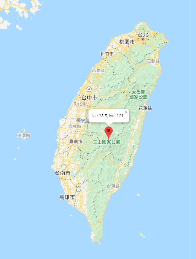
↑ 再來,新增一個點資料圖徵。
        var infowindow = new google.maps.InfoWindow({
            content: `lat: 23.5, lng: 121`
        });
↑ 我們想為點加上一些註釋,我們可以新增一個資訊視窗(InfoWindow),
        marker.addListener('click', function () {
            infowindow.open(gMap, marker);
        });
↑ 對marker新增一個click事件,點擊後打開資訊視窗。
並且把Infowindow綁在marker上面,讓它相對於marker顯示在地圖上。
那要怎麼在WebGIS上找到自己的位置呢?
別擔心!HTML5提供了geolocation API可以進行定位!
        var x = document.getElementById("demo");
        function getLocation() {
            if (navigator.geolocation) {
                navigator.geolocation.getCurrentPosition(showPosition);
            } else {
                x.innerHTML = "Geolocation is not supported by this browser.";
            }
        }

        function showPosition(position) {
            x.innerHTML = "Latitude: " + position.coords.latitude +
                "<br>Longitude: " + position.coords.longitude;
        }
↑ 這是w3schools上面的一個範例: https://www.w3schools.com/html/html5_geolocation.asp
看到這裡應該會有幾個疑問:

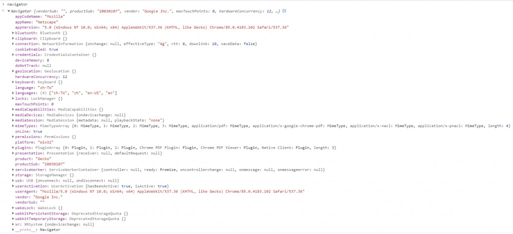
geolocation API可以取得客戶端使用瀏覽器的位置,其原理有二:
因此,如果我們在自家電腦用geolocation API,通常誤差都蠻大的,
因為少了GPS的輔助,一樣的位置使用手機定位,會精確許多。
此外,geolocation API不支援http連線,所以網站需要申請SSL憑證,
轉成https再使用吧!不然也可以找憑證產生的外掛程式(誤
接著我們把showPosition加入剛剛寫的點資料圖徵的方式顯示在地圖上。
       var marker;
       var infowindow;
       function showPosition(position) {
            var lng = position.coords.longitude;
            var lat = position.coords.latitude

            marker = new google.maps.Marker({
                position: { lat: lat, lng: lng },
                map: gMap,
                title: `lat: ${ lat }, lng: ${ lng }`
            });
            infowindow = new google.maps.InfoWindow({
                content: `lat: ${ lat }, lng: ${ lng }`
            });
            marker.addListener('click', function () {
                infowindow.open(gmap, marker);
            });
        }
在這邊,showPosition是作為navigator.geolocation.getCurrentPosition(callback);
的callback function,也就是geolocation定位完後,才會呼叫這個function,
並且把定位結果資訊傳入callback function中。
getLocation();
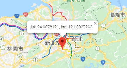
↑ 呼叫getLocation方法定位。
這裡就是我家的位置啦!
同場加映~
內政部TGOS圖台提供的門牌地址定位服務,可以依地址比對取得座標。
官網上有ASP.NET後端呼叫的範例、以及TGOS API呼叫的範例。這裡直接附上寫好的function給大家使用! 其實是我懶得一步一步解釋
(記得要先引用TGOS Map API)
        function Locate() {
            if (!(this instanceof Locate)) {
                return new Locate();
            }
        }

        Locate.prototype.ByAddress = function (address, callback) {
            var locator = new TGOS.TGLocateService();
            var result = {
                x: undefined,
                y: undefined,
                pointList: [],
                errorMessage: ''
            }
            callback = callback || function () { }

            locator.locateWGS84({ address: address }, function (e, status) {
                if (status === TGOS.TGLocatorStatus.OK) {
                    result.x = e[0].geometry.location.x;
                    result.y = e[0].geometry.location.y;
                    result.pointList.push({
                        county: e[0].addressComponents.county,
                        town: e[0].addressComponents.town,
                        addressComponents: e[0].addressComponents,
                        address: e[0].formattedAddress,
                        x: e[0].geometry.location.x,
                        y: e[0].geometry.location.y
                    });

                } else if (status === TGOS.TGLocatorStatus.TOO_MANY_RESULTS) {
                    result.pointList = e.map(function (item) {
                        return {
                            county: item.addressComponents.county,
                            town: item.addressComponents.town,
                            addressComponents: item.addressComponents,
                            address: item.formattedAddress,
                            x: item.geometry.location.x,
                            y: item.geometry.location.y
                        }
                    });
                    result.errorMessage = '地址查詢結果過多!';

                } else {
                    console.log('查無地址!');
                    result.errorMessage = '查無地址!';
                }

                callback(result);
            });

            this.result = result;
        }
↑ 這邊把TGOS.TGLocateService()封裝,自定義callback回傳參數,
看不懂的朋友別擔心!未來會有一篇專門講callback & promise!
        var locate = new Locate();
        locate.ByAddress('臺北市信義區市府路45號', function (result) {
            console.log(result);
        });
↑ 呼叫的方式只需要兩行。
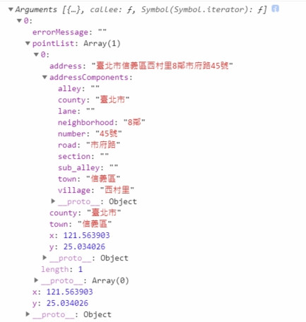
↑ 回傳的結果
雖然跟實際的經緯度還是有一點點誤差,不過也算是很好用的服務了!難的是申請API Key
今天講了Html5 geolocation API,以及TGOS 全國門牌地址定位服務 API,
如果今天研究一個從來沒用過的API,除了看API文件以外,要怎麼去Try?
下一篇,會深入講解JS的Function以及Arguments,教你怎麼一下就上手別人的API,
也會順便講一些ES6的寫法。
欲知後事如何,且聽下回分解。![]()
