
延續上一篇「如何運用HERE JavaScript快速建立前端的網頁顯示地圖」,這篇將快速介紹,使用地圖常見的運用案例,如何於圖面上顯示出導航路徑。
更多的細節與內容,請參考HERE Developer :
(https://developer.here.com/documentation/maps/3.1.18.1/dev_guide/topics/routing.html)
這個部分,在此篇文章將不再另外說明,請參考先前的文章「如何運用HERE JavaScript快速建立前端的網頁顯示地圖」(https://ithelp.ithome.com.tw/articles/10233305)
「起點,「終點與「方式」為路徑規劃的基本資訊。可依自己的需求,定義出不同的路徑計算結果。
「方式」可細分為:
-最快(fastest)或最短(shortest)路徑。
-汽車(car),行人(pedestrian),單車(bicycle)或卡車(truck)的路徑計算。
-路經規劃是否考量即時交通資訊(traffic:enabled / traffic:disabled)。
例如,mode: 'fastest;car;traffic:enabled' ,表示路徑規劃根據汽車可行駛的路線,並考量交通狀況計算出最塊路徑。
      const request = {
         mode: 'fastest;car;traffic:enabled',
         // The routing mode: mode=shortest;pedestrian ; mode=fastest;car;traffic:enabled ; mode=fastest;car;traffic:disabled ; fastest;bicycle  ; pedestrian
         waypoint0: 'geo!25.037528,121.563556',
         waypoint1: 'geo!25.066401,121.480946',
         representation: 'display'
      };
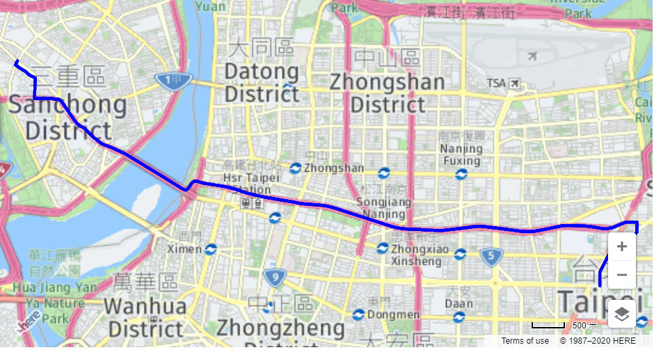
呼叫HERE Routing Service,利用calculateRoute方式,獲得路徑的Shape資訊,將Shape轉換polyline,而後加入polyline object顯示於地圖上。
      //Initialize routing service
      const router = platform.getRoutingService();
      router.calculateRoute(request, response => {
         //Parse the route's shape
         const shape = response.response.route[0].shape.map(x => x.split(','));
         const linestring = new H.geo.LineString();
         shape.forEach(s => linestring.pushLatLngAlt(s[0], s[1]));
         //Create a polyline with the shape
         const routeLine = new H.map.Polyline(linestring, {
            style: { strokeColor: 'blue', lineWidth: 5 }
         });
         //Add route to map
         map.addObject(routeLine);
最後,依據路徑結果的外接矩行getBoundingBox(),重新調整地圖縮放比例,以便能展示完整的路徑計算結果。
//Zoom to bounds of the route shape
map.getViewModel().setLookAtData({ bounds: routeLine.getBoundingBox() });
codebase :
<html>

<head>
    <title>HERE MAP By JS</title>
    <meta name="viewport" content="initial-scale=1.0,width=device-width" />
    <script src="https://js.api.here.com/v3/3.1/mapsjs-core.js" type="text/javascript" charset="utf-8"></script>
    <script src="https://js.api.here.com/v3/3.1/mapsjs-core-legacy.js" type="text/javascript" charset="utf-8"></script>
    <script src="https://js.api.here.com/v3/3.1/mapsjs-service.js" type="text/javascript" charset="utf-8"></script>
    <script src="https://js.api.here.com/v3/3.1/mapsjs-service-legacy.js" type="text/javascript" charset="utf-8"></script>
    <script src="https://js.api.here.com/v3/3.1/mapsjs-mapevents.js"
    type="text/javascript" charset="utf-8"></script>
    <script src="https://js.api.here.com/v3/3.1/mapsjs-ui.js" type="text/javascript" charset="utf-8"></script>
    <link rel="stylesheet" type="text/css" href="https://js.api.here.com/v3/3.1/mapsjs-ui.css" />
</head>

<body>
    <div style="width: 100%; height: 500px" id="mapContainer"></div>
    <script>
    // Create a Platform object:
    var platform = new H.service.Platform({
        'apikey': '[Your Apikey]'
    });

    // Get an object containing the default map layers:
    var defaultLayers = platform.createDefaultLayers({ lg: 'CHT', lg2: 'ENG', size:512 });

    // Instantiate the map using the vecor map with the
    // default style as the base layer:
    var map = new H.Map(
        document.getElementById('mapContainer'),
        defaultLayers.raster.normal.map, {
            zoom: 15,
            center: { lat: 25.037975, lng: 121.5493 },
        });

    // Enable the event system on the map instance:
    var mapEvents = new H.mapevents.MapEvents(map);

    // Add event listener:
    map.addEventListener('tap', function(evt) {
        // Log 'tap' and 'mouse' events:
        console.log(evt.type, evt.currentPointer.type);
    });

    // Instantiate the default behavior, providing the mapEvents object:
    var behavior = new H.mapevents.Behavior(mapEvents);


    // Create the default UI:
     var ui = H.ui.UI.createDefault(map, defaultLayers, 'zh-CN')

     //Begin routing
      //Configure transportation mode, start, end points
      const request = {
         mode: 'fastest;car;traffic:enabled',
         // The routing mode: mode=shortest;pedestrian ; mode=fastest;car;traffic:enabled ; mode=fastest;car;traffic:disabled ; fastest;bicycle  ; pedestrian
         waypoint0: 'geo!25.037528,121.563556',
         waypoint1: 'geo!25.066401,121.480946',
         representation: 'display'
      };
      //Initialize routing service
      const router = platform.getRoutingService();
      router.calculateRoute(request, response => {
         //Parse the route's shape
         const shape = response.response.route[0].shape.map(x => x.split(','));
         const linestring = new H.geo.LineString();
         shape.forEach(s => linestring.pushLatLngAlt(s[0], s[1]));
         //Create a polyline with the shape
         const routeLine = new H.map.Polyline(linestring, {
            style: { strokeColor: 'blue', lineWidth: 5 }
         });
         //Add route to map
         map.addObject(routeLine);
         //Zoom to bounds of the route shape
         map.getViewModel().setLookAtData({ bounds: routeLine.getBoundingBox() });
      });

    </script>
</body>

</html>
 D.C
D.C
